Tuesday, June 10, 2008

Changes

Sorry about the switch to comment moderating, folks. Apparently I've gained enough web traffic to attract people who have nothing better to do with their time than use the comments section as their own personal grandstand - and then stoop to being petty and insulting when I opt not to allow that to continue.

A note to these people: I don't write this blog so you can waste my time arguing about what I write. There are other blogs out there whose owners will be more than happy to do that. If you're simply trolling for a fight, it's my prerogative to delete your comment. It's my blog. If you have a problem with that, get your own blog or go away.

Guess I should remember the warning of more experienced denizens of the blogosphere and internet forums: Don't Feed The Trolls.

In the Humorous Vein #6

Monday, June 9, 2008

Geoarchaeology: Footprints in ash and the first people in North America

National Geographic News has published an article about the results of new dating methods used on footprints in volcanic ash in Mexico.

The quarry where the footprints were discovered in 2003 is located in Mexico's
Valsequillo Basin (and near the Cerro Toluquilla volcano). The footprints were originally dated in 2005, when an international team of geoarchaeologists concluded that the footprints had been created more than 40,000 years ago.

(Image from the NatGeo website, credited to Silvia Gonzalez, Liverpool John Moores University, United Kingdom
.)


There seems to be some confusion between various articles about the ash itself - in another 2005 article, the ash is described as being 1.3 M.Y.O. - far too old for anyone to have created the footprints in it while it was still fresh. The new NatGeo article raises this question, but says that "dating the ash is complicated by the fact that an eruption occurred underwater, said Silvia Gonzalez of Liverpool John Moores University, in the United Kingdom." What's strange is that in the Bristol article, the explanation is this:
"The footprints were preserved as trace fossils in volcanic ash along what was once the shoreline of an ancient volcanic lake. Climate variations and the eruption of the Cerro Toluquilla volcano caused lake levels to rise and fall, exposing the Xalnene volcanic ash layer. Early Americans walked across this new shoreline, leaving behind footprints that soon became covered in more ash and lake sediments. The trails became submerged when the water levels rose again, preserving the footprints."
Both quotes were made by Dr. Gonzales, which is somewhat confusing. I don't quite understand why the discrepancy exists, but I suspect that at least one of the articles has fallen victim to some bad editing.

Anyway, the short of all this editing mess is that the 1.3 Ma age is a combination of the age of the ash-producing magma and bedrock pulverized by the eruption. The new study used "optically stimulated luminescence" to determine when the hardened ash was last exposed to sunlight (or volcanic heat), and came up with an age of 40,000 years. Sediment below the ash layer was dated to 70-100,000 years, and above it to 9-40,000 years. This means that the footprints should be at least 40,000 years old, and possibly more, since the ash layer could have sat around for a good long time before being buried by the younger sediments.

I find all this pretty exciting because it has to do with an ongoing (but hopefully dying) debate in the archaeological community about when the first humans arrived in North America. It was a favorite topic of the professor who taught my Intro to Archaeology class, and it's been going on for a good long time now - since the late 1960s, and there are still people arguing about it, although I think the Clovis holdouts pretty much just clinging to dogma by now. "Clovis First" holds that the Clovis people, a Paleoindian culture that first appears in the archaeological record about 13,000 years ago, were the first migrants to the North American continent. The first Clovis points (spear and arrowheads), which have a distinctive "flute" down the center of the point, were discovered in New Mexico in the late 1930s, and have since been found all over North America (and even in parts of Central and northern South America).

For a long time, it was accepted that the Clovis people were the first to show up. Then, in the 1970s, James Adavasio discovered material at the Meadowcroft Rockshelter near Avella, Pennsylvania, that was radiocarbon dated to 16-19 Ka. In 2004, a site in South Carolina called Topper produced charcoal fragments that were radiocarbon dated to 50 Ka, and were interlayered with what appeared to be worked stone tools. There were all sorts of disputes about the accuracy of the carbon dating - some people claimed that the site was contaminated with older material, or that the dating was done incorrectly, or that the charcoal had resulted from natural causes (wildfires or lightning strikes), or that the stone wasn't worked but had been chipped by natural forces.

Other sites (like Monte Verde in Chile, dated to 14.5 Ka) have been discovered that pretty much negate the Clovis First theory, as they change the timing of migrations to North America over the Bering land bridge. (The Clovis people couldn't have been the first over the bridge if the Monte Verde culture, which is more than a thousand years older, made it all the way to South America before the Clovis people did. The Monte Verde research also sparked the theory that the migrations were mainly along coastal waterways, and not limited to land, as had been previously thought.)

The whole thing is a great example of how theories evolve - and it's neat that I can finally use something I picked up in my anthropology minor! (I also think it's pretty cool that the evidence for really old cultures in the Americas is preserved in volcanic ash, but that's just me.)
Thursday, June 5, 2008

Stop! In the name of the carbonate!

I just came across this news item, which discusses a proposal a new method for slowing and/or diverting a lava flow. The original article is titled "How to stop or slow down lava flows", by R.D. Schuiling in the International Journal of Global Environmental Issues, 2008, vol. 8, p. 282-285. I can't access the journal itself, but the summary goes like this:

"Schuiling believes a geochemical approach might be effective in controlling lava flows across the globe. He explains that certain common rocks, namely dolomite, or limestone, will react strongly with hot lava at 1100-1200 Celsius. The chemical reaction that ensues is highly endothermic, which means it requires heat, and this would be supplied by the hot lava.

"The decarbonation of limestone by the hot lava will therefore rapidly cool the volcanic outpourings, making it far more viscous and quicker to solidify. The reaction will leave behind solid calcium and magnesium oxide mixtures - pyroxenes or melilites depending on the specific type of lava. The process would also release some carbon dioxide.

"He suggests that large chunks of dolomite or limestone blocks could be thrown on to lava from the sides, or from above by helicopters or airplanes, or even by an aerial cable system passing over the flow. An alternative approach might be to quickly build a wall of limestone blocks in the path of the advancing lava flow. In places where a future lava flow would cause great material damage, such walls could even be constructed as a forward defense before a new eruption." (Eurekalert)

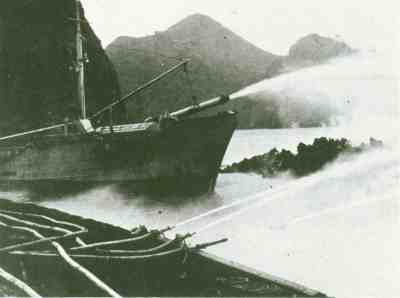
I'm kind of skeptical about this. Methods of stopping or diverting lava flows have been tried for centuries, with varying success. The Neapolitans called on their patron San Gennaro to turn away lava flows produced in the 1631 eruption of Mount Vesuvius (although one would think that the flows "spared" Naples more because their supply was cut off than because of the intervention of a 4th-century martyr). The Icelandic town of Heimaey was able to use seawater cannons to partially divert lava flows from closing off the entrance to their harbor in the eruption of Eldfell in 1973. (I seem to remember there were some questions as to whether the flows were diverted because the method actually worked, or if there was some change in the eruption that slowed down the effusion rate anyway - I'll have to check on that.) And in 1935, 1940 and 1942, Mauna Loa lava flows threatening Hilo were bombed in an attempt to keep them from reaching the city (with no significant effects, although studies since then have suggested that better targeted aerial bombing "has a substantial probability of success for diversion of lava"[Lockwood and Torgerson, 1980]).

(Above, USGS image of ships pumping seawater onto the forward margin of the Heimaey lava flow, Photograph courtesy of Sigurgeir Jónasson, March 1973. To right, B-18s over Mauna Loa eruption, April 1940, from the Hawaii Aviation website.)

And, of course, there's always the Jersey barrier solution employed by Tommy Lee Jones in Volcano.

While I'm sure that the chemistry behind the new idea is sound, I have questions about the physical aspects of the situation. A lava flow, even a really fluid one, has a lot of mass, and the source of the flow is constantly adding more. A flow doesn't stop unless its source stops producing lava. It can sometimes be diverted (naturally or not), but more often than not it's simply going to go around or over an obstacle, and keep on moving in the same direction as before. Then you have a whole new set of problems: Where is the diverted lava going to go? How long will the barrier last, and if it fails, are you going to have lava going in multiple directions? This is the very reason that Volcano's Jersey barrier solution was unrealistic - even if they could hold back the lava in the first place, the lava had to go somewhere, and with that kind of force, the barriers wouldn't last very long anyway.

Knowing the capability of lava flows for pretty much bulldozing over anything in their way, I don't think that building a limestone wall in the way of one would be very effective. I could be wrong, though; basaltic lava flows on Hawaii become channelized all the time by their own debris, and I suppose if you were able to dump enough limestone on one in strategic locations, you might be able to divert it. I do think, despite being skeptical of the idea, that it would certainly be really cool if it did work. Not to mention that it might actually be affordable, since limestone is common in nature and used widely for construction. (More affordable than bombing, anyway.)

Come to think of it, Jersey barriers are made out of concrete. Concrete contains cement, and cement is made partially out of limestone. Hmm. Maybe TLJ had something going there...


References:

"Volcano taming: Could geochemistry save lives during volcanic eruptions?" (Eurekalert)

Schuiling, R.D., 2008, How to stop or slow down lava flows: Int. J. Global Environmental Issues, 2008, vol.8, p.282-285 (Link to abstract)

Man Against the Volcano: The Eruption on Heimaey, Vestmannaeyjar, Iceland (USGS Publication)

Lava-Cooling Operations During the 1973 Eruption of Eldfell Volcano,
Heimaey, Vestmannaeyjar, Iceland
: U.S. Geological Survey Open-File Report 97-724

Lockwood, J.P. and Torgerson, F.A., 1980, Diversion of lava flows by aerial bombing — lessons from Mauna Loa volcano, Hawaii: Bulletin of Volcanology, vol. 43, no. 4, p.727-741. (Link to abstract)

Wednesday, June 4, 2008

Suburban excursions

I went on a short hike recently to find samples of Virginia rocks to fill out my collection and use for a presentation I'm going to be making at a career fair. Because I didn't feel like trekking all the way out to the mountains by myself (not at all environmentally conscious!) I went looking for them in the stream beds near my house.

I live in a pretty generic suburban area, but much of the housing in my neighborhood was built in the 50s and 60s, and it seems that they weren't so keen on destroying all of the natural environment back then. As a result, there are a lot of wooded areas and a number of small streams that cut through Coastal Plain sediments and drain into the Potomac. A geologic map of the area calls the deposits "Qte: Low-level fluvial and estuarine deposits (Pleistocene)." Mainly, it's a lot of sand with pebble-to-cobble sized clasts and lots of of iron oxide chunks - overlain, naturally, by every polymorph of poison ivy conceived of by nature. It's an area I'm familiar with, having spent a great deal of time there when I was young, getting mucky and probably exposing myself to any number of diseases and bacteria (I didn't actually go IN the stream, but even with wading boots, it's hard to avoid getting a little wet. Hooray for rubbing alcohol and soap.)

The streams themselves are supposedly spring-fed, and there are a few roads and subdivisions with "Springs" in the name. I suspect more water comes from runoff these days, since there are a lot of paved surfaces in the area, but I can vouch for the existence of the springs - one part of my yard and the sidewalk adjacent are constantly wet, no matter what the weather has been like, and none of the drains in our house connect to the sewers in that area. Wet enough, in fact, that's it's created a great example of differential erosion in the concrete curb where the water drains to the street.

Anyway, back to the rocks. Here are some of the clasts I picked up:

Antietam metasandstone: An old friend, and one I was expecting to find in abundance (which I did). Very distinctive Skolithos trace fossils (worm burrows), which make it pretty easy to spot. This is a Chilhowee Group rock
(shallow marine and fluvial siliciclastics deposited in the late Proterozoic and early Cambrian), and makes up one of the resistant layers in the BR. (Screw is ~1 in.) I don't call this quartzite, as some publications have done, because individual quartz grains are still visible. (My undergrad adviser had a major pet peeve about this, and I've inherited it.) It's very well cemented and may have been metamorphosed to some extent, but in every sample I've looked at, the sand grains are still distinguishable, and haven't been recrystallized enough to call it a quartzite. That degree of recrystallization would also have destroyed the Skolithos tubes, which hasn't happened in these samples.

A closeup of one of the tubes.

Sandstone with cross-stratification: Lots of this, surprisingly. The cross-stratification ranged from mm to cm-scale layers (in the largest cobble I picked up). I'm betting Chilhowee Group again, possibly Weverton (braided stream deposits) or another part of the Antietam.

Coarse-grained sandstone: I was hoping this would be an arkose when I cleaned the mud off it, but it looks to be just a sandstone with some oxides in the cement. No feldspar cleavage surfaces, as far as I can tell, and it's not really close enough to a source area for feldspar to have survived. Could be another bit of the Weverton - I wouldn't call it Antietam, because the Antietam sandstone tends to be made of very pure, very white quartz, and I've never seen it with oxidized cement.

Chert: Again, unsurprising; this stuff shows up a lot in stream beds. I thought at first it might be micritic limestone, but it won't scratch or fizz, so chert's the verdict. It probably came from a carbonate unit like the Lincolnshire Formation (middle Ordovician cherty limestone).

Mystery rock! Not really what the story on this is - it looks like a siltstone with inclusions of little clay flakes.


Anthracite coal: No photos of this, but I'm sure everyone can guess what it looks like. I was a bit surprised to find it, as this particular stream doesn't run anywhere near railroad tracks, which is usually where I find stray coal in my area. I have doubts that it would have survived the trip from western Virginia to the Coastal Plain, so I don't think it arrived here naturally. Perhaps it was dumped or washed in from someone's yard - the land around my house used to be part of a large farm, so maybe it's historic coal.

I really want to show off the cross-bedding in the large cobble I collected, but I haven't had a chance to clean it properly just yet. I've also found a few other samples that I'm not completely sure of, but again, haven't had time to sit down with the handlens and camera, so they'll have to wait until the weekend.

Some good resources for Virginia geology:

USGS Geolex Database: This is a great website - it allows you to look up recognized geologic units by age, name, location (down to the county level), rock type, even by author citation. Units are displayed with alternate names, "areal extent", type localities, subunits, and a history of the names and descriptions that have been applied to the unit, even back into the 19th century, with the authors and publications they're found in.

Geology of Virginia (College of William & Mary): A very good basic overview of Virginia geology, with generalized province and geologic maps to download, and a selection of outcrop and sample photos.

Geological Evolution of Virginia and the Mid-Atlantic Region (JMU): Oddly organized, in my opinion, but useful for quick reference.

Virginia Department of Mines, Minerals and Energy, Division of Mineral Resources: Archived issues of the Virginia Minerals newsletter, some open-file reports, and a source for info on diamonds in Virginia.

Monday, June 2, 2008

Job Opportunity

Does anyone out there have students or friends who've finished their undergrad and are looking for a job? Since I'm getting ready to run away to graduate school, my organization will be looking to replace me by the end of the summer. In the interest of not receiving a lot more spam email than we already do (and since I try to blog pseudonymously), we're not posting the info online just yet, but I can give a basic rundown here, and I'll be happy to send more info by email if anyone's interested.
"Outreach Assistant. This full-time entry-level position reports to the Manager of Outreach. Duties include writing and editing, preparing electronic documents and updating Web pages, and various clerical functions associated with development of materials for the organization's national earth science public awareness campaign, as well as earth science curriculum products and professional development services."
I end up working on more than this, most days, because the staff here love to have someone available with background knowledge of geology; I'm currently producing a geology-oriented poster series and helping with research for an environmental science textbook. The job is in the Northern Virginia area, which is affordable if you're willing to share living space or have a spouse/S.O. who's contributing a salary. (The commuting is icky, but there's really no way to avoid it.) On the plus side, you're close to DC, within a few hours of Richmond, Charlottesville and the Shenandoahs, Annapolis, and Baltimore.

The ideal candidate would be someone who can commit a year or more to the job, has at least an undergraduate degree in geology or environmental science, and either lives in the DC metro area or is willing and able to move here. An interest in earth science education is also a plus, but not required.

If any of you know of anybody qualified, let me know! They can contact me with the email listed on the blog, and we'll go from there.

Sunday, June 1, 2008