Tuesday, April 27, 2010

Large Santiaguito eruption yesterday morning

As has already been reported on the excellent Volcanism Blog, Santiaguito experienced a large eruption yesterday morning. Here's a translated announcement that made its way to me from Gustavo Chigna of the Instituto Nacional de Sismología, Vulcanología, Meteorología e Hidrología (INSIVUMEH):
This morning at 06:50 to 09:45 Santiaguito entered a volcanic eruption with 4 face of crater collapses and pyroclastic flows generated within the gullies on the southern flank. The ash column reached heights of 27,000 feet in a westerly direction, northwest and north, forcing the closure of village schools southwest of Santiaguito and in the Quetzaltenango area. A similar eruption to this has not been seen since 1989. The ash is still scattered at 24,000 feet and civil aeronautics alerted air traffic to avoid the plume within a radius of 80 km. 
If you haven't seen my earlier posts on Santiaguito (my study area), here's a little background: The Santiaguito lava dome complex is a set of four lava domes at the base of the now inactive Santa Maria Volcano. Currently only one of the domes (El Caliente) is active, and this is the site of yesterday's eruption. Typically, activity on Caliente is limited to 1-3 km high ash-and-gas explosions every hour or two, accompanied by the extrusion of a blocky lava flow from Caliente's summit, occasional pyroclastic flows, and almost continuous rockfalls. Yesterday's event appears to have been quite a bit larger than the usual activity, and has disrupted life for the people living near the domes.

The last eruption at Caliente of this magnitude occurred in 1989, and produced similar ashfall and pyroclastic flows in the drainages on the south side of the domes. Before that, there was the 1973 event, a large collapse and pyroclastic flow from the Brujo lava dome (the last dome to the west of Caliente). Brujo is no longer erupting today, although there is some fumarolic (mostly water vapor) activity. (For more information on the 1973 event, have a look at this paper: Rose, W.I., 1973, Nuée ardente from Santiaguito volcano, April 1973: Bulletin of Volcanology, v. 37, p. 365-371.)

Dealing with ashfall isn't very fun, as folks in Europe can attest, since it gets into everything and makes breathing uncomfortable, if not difficult. On my last field excursion to Guatemala, we were lucky to be out of the way of the ash plume from Caliente - the prevailing winds kept it blowing in the opposite direction of our camp. I'm also quite glad that this event occurred after we were off the domes, because it might have meant dealing with major ashfall at the least, and possibly pyroclastic flows from the column collapse.

Here's some reporting from a few other news sources (this also repeats what was posted on the Volcanism Blog, but I wanted to note the articles that had photos):

El volcán Santiaguito hace declarar alerta naranja - El Periodico (in Spanish, with eruption photo)
Elevan a naranja la alerta en Guatemala por el volcán Santiaguito - EcoDiario (also in Spanish; it appears to have a photo of a large eruption, but I'm not sure if it's Santiaguito or just a stock photo)
Alerta Naranja por ceniza de volcán - El Quetzalteco (in Spanish, with a photo of the reduced visibility on the road leading to the north side of Santa Maria)
Declaran en Guatemala la alerta naranja por la erupción del volcán Santiaguito - Que Es (in Spanish, with a photo that appears to be of Pacaya rather than the domes at Santiaguito)
"Santiaguito Volcano showers sand and ash over Guatemala" - The Australian (via the Agence France-Presse)

My previous posts on Santiaguito and Santa Maria:
Santiagutio Volcano Observatory
Looking backward: Past eruptions at Volcán Santa Maria
Santiaguito lava dome complex
Lava domes, coffee, and a little bit of shaking

Friday, April 23, 2010

Accretionary Wedge #24: My geologic hero

In considering who I would write about as my geologic hero, I of course had to consider my undergraduate advisor, who I've written about before. (You all know him from this blog, if you've been keeping up with the adventures of William & Mary's Geology Department.) But that would essentially be a rehash of something I've already talked about. Although Chuck was (and still is) an immense influence on my growth as a geologist and a writer, I think that having almost two years of grad school under my belt means I can examine influences a little farther afield.

But who do I look up to as a volcanologist? I'm relatively new to the volcanological scene, and I haven't had the chance to interact with many of the leading lights yet (although quite a few of them are right here at UB). If I were to consider someone who's had an incredible influence on my entire field of study, however, I would tend to look further into the past...and I've come up with one volcanologist who fits the bill. 

My pick? Thomas A. Jaggar (1871–1953), an MIT professor who was the founder and first director of the Hawaii Volcano Observatory (HVO). While not the first of its kind in the world (that distinction goes to the one at Vesuvius, which has been around since 1847), the HVO certainly kick-started volcano monitoring in the US. Here's a bit from the HVO History page about his motivation:
"Jaggar saw the need for full-time, on-site study of volcanoes. He had long deplored that to date, especially in America, it was only after news of an eruption was received that geologists rushed from academic centers to study volcanism. There was generally no trained observer there beforehand, and scientists from afar often arrived after the eruption was over. There was then only one volcano observatory in the world, that at Vesuvius established in 1847. Jaggar thought America needed one."
On-site observation of volcanic processes is the key to deciphering the history of a volcano, and gives us the tools to make inferences about the past of volcanoes that have never been observed in eruption. Dr. Jaggar, as he made visits to Martinique following the 1902 of Mount Pelee, and followed them with expeditions to the sites of earthquakes and eruptions in Italy, the Aleutians, Central America, and Japan, became increasingly convinced that such trips were a too-short, inadequate way of observing Earth processes. In 1910, with the support with Lorrin Andrews Thurston, a Honolulu lawyer and businessman; this collaboration led to the formation of the Hawaii Volcano Research Association and, with the financial help of Jaggar's home institution of MIT, the establishment of the Hawaii Volcano Observatory in 1912. 


Dr. Jaggar (second from left) preparing to measure the temperature of the Halema`uma`u lava lake in 1917, with stylish hat. My field hats are not even close to that stylish, nor have I ever attempted to do field work in a tie. From the HVO website.

Jaggar went on to work at the Observatory for almost 30 years, during which HVO researchers released more than 1,200 press reports and bulletins about volcanic activity; published The Volcano Letter, a weekly and then monthly report that lasted from 1925-1955; and published copiously in other periodicals outside the Observatory. Jaggar designed and implemented the Whitney Laboratory of Seismology beneath the Observatory (the first site of continuous seismic monitoring in Hawaii), conducted experiments in the Kilauea caldera to monitor subsurface temperatures, and helped pioneer the use of tiltmeters to record the deformation on an active volcano (among other things). The research that's been conducted since at the HVO has been invaluable for the field of volcanology, of course, and the HVO has been a model for other observatories around the world. But why do I think Jagger is a good hero for me? Because he hit on one of the reasons that I wanted to study volcanology in the first place:
"The main object of the work should be humanitarian...prediction and methods of protecting life and property on the basis of sound scientific achievement."
That's the reason I want to study volcanoes - not just for the sake of gaining knowledge, although that's an admirable goal as well. I want my work to be useful to more than just other scientists. It's been fairly obvious recently that most of the world has no idea how to live with the reality of volcanoes in their midst, even when the science of volcanology is firmly in place to study them. There needs to be a working link between science and society, and volcanology - a science which deals with one of the most visible and devastating geologic phenomena out there - should be a major part of that. In my opinion, Dr. Jaggar hit that one spot-on.

Like many heroes, Thomas Jaggar isn't perfect; in order to stretch his limited funding during the building of the Observatory, he allowed convict labor on the site, something that no one would consider nowadays. (The prison camp that supplied the labor was located at the current site of the Kilauea Military Camp in Hawaii Volcanoes National Park). His supporter Lorrin Thurston helped lead the overthrew of Queen Liliuokalani the native monarchy of Hawaii in 1893. Both of them participated in somewhat unsafe experiments (although I will admit that if I had the opportunity to chuck logs into an active lava lake, I probably wouldn't pass it up either).

But it also seemed that he had a good sense of humor - a plus for anyone who works on volcanoes, considering all the hazards and difficulties - and a very tolerant wife (who also apparently had a good sense of humor). He dedicated one of his publications to her with the following lines, in fact: 

"To helpmeet and campmate, ISABEL JAGGAR,  Whose horse crushed her against a tree . . . /, Whose gloves fell into a red hot crack and burned up . . . /, Who slept in a lava tunnel beside the immortal remains of a desiccated billy goat . . . /, And loved it all."
A pioneer in his field, a snazzy dresser and a good sense of humor? Something any volcanologist would aspire to.

Thursday, April 22, 2010

Earth Day Edition: Where on (Google) Earth # 200!

Perhaps I was a little quick jumping on the answer for Callan's first WoGE, but I couldn't resist...a time-lapse series of shots of the Spirit Lake logjam was an excellent (and timely) choice, since the anniversary of the 1980 Mount St. Helens eruption is coming up (May 18th!). The logjam that's shifting its position in Callan's pictures was created when trees, downed by the eruption's lateral blast, were washed into Spirit lake by water displaced in the initial debris avalanche. They've been floating on Spirit Lake ever since, and as you can see in the photos, they tend to migrate.

I've decided to run the 200th Wo(G)E on Earth Day, since it's also the 40th anniversary of the first Earth Day. What better way to take advantage of the date than to use Wo(G)E to highlight the beauty and the geology we can find on Earth?

So in this edition, not only are you going to see a lovely scene as revealed by Google Earth...you're going to see four, in honor of the four decades of celebrating Earth Day. (Yes, I'm evil. Hahahahaha!) And they're not just pretty pictures, but also locations that are geologically and environmentally significant. So here's the deal: Find the coordinates for each location and take a stab at describing why it's geologically significant. First person to come up with accurate locations and a reasonable explanation for each gets to host the next edition of WoGE; if you don't have a blog, you're welcome to choose a location and I'll be happy to post it for you.

A hint or two: Pay attention to the scalebars; altitudes were varied to make the images more aesthetically pleasing. No two features are on the same continent, and a few aren't on continents at all. There's not any particular underlying theme here - mostly I've just tried to choose remote locations. Click on the images to view them full-size.

Because I've made this Wo(G)E a bit more time-consuming by adding multiple locations, I'm not invoking the Schott Rule. First one to four wins!


PS - I get a lot of spam, so my comments are moderated. Don't worry if your answer doesn't show up right away - I receive them all in the order that they were submitted, so your position in the race is preserved. Have fun!

Friday, April 16, 2010

Volcano Vocab #3: Tephra

Today's volcano word is tephra, another term that's directly related to the Eyjafjallajökull- Fimmvörduháls eruptions going on in Iceland at the moment. Tephra ("teff-rah") refers to any fragmented material thrown from a volcanic vent during an explosive eruption. It comes in different sizes, all of which have their own names (just to make things even more difficult!)

Bombs or blocks are large rocks - 64 mm and greater in diameter (cobble to boulder sized; see the photo at left, which is an example of a really big bomb on a scoria cone on Mount Etna). Lapilli are smaller, from 2 mm to 64 mm (the size of the material underneath the bomb at left). Ash is any material smaller than 2 mm, and is one of the main constituents of a volcanic eruption column, such as the one that's disrupting air traffic over northern Europe at the moment. Volcanic ash is composed of fragmented glass, rock, and phenocrysts (crystals), unlike the ash you get from fires (which is mostly carbonized organic material).

The other things that make up an eruption column are typically gases (including water vapor), ambient air that's been entrained and heated, and some lapilli and bomb-sized particles. Some recent news reports have been saying things like "ash and smoke" to describe the Eyjafjallajökull-Fimmvörduháls eruption column, which is incorrect. There is no "smoke" in an eruption column, at least in the sense that most people think of it (as a byproduct of burning materials). The column appears to be smoky, but only because of the presence of the ash, which is generally some shade of gray or black.* (The photo below, from a February 2010 eruption of the Caliente dome at Santiaguito, is quite gray to begin with, but I can guarantee that it's not because something in the vent is burning.)

Tephra is a major hazard associated with volcanoes. Bombs tend to be more of a problem in the vicinity of a volcano, but as many people in northern Europe are finding out, smaller particles like lapilli and ash can travel much higher and farther. Ash from a powerful eruption can reach the upper atmosphere, far higher than airplanes can fly; and because glass makes up a good portion of those ash particles, any plane that does fly through an ash cloud risks sucking glassy particles into its engines, where the glass can melt and re-solidify. This is bad - it could mean total engine failure, which is what happened to a flight over Alaska in 1989. No sane pilot is going to fly a plane into that.

So if you're stuck waiting for a flight to or from Europe, just remember: it's a lot better than risking a plane crash. And you can probably look forward to some spectacular sunsets.


*Okay, maybe some lichen is getting toasted, but that still doesn't mean you can call ash "smoke".

Tuesday, April 13, 2010

Volcano Vocab #2: Jökulhlaup

Today's obscure volcanologically-related word is jökulhlaup ("yer-kul-hloyp", "YO-kel-yawp" and "yo-kul-h-loip" in varying pronunciations), which is an Icelandic word for glacial outburst floods, both of water and lahars, formed when a subglacial eruption occurs. The water for these floods is formed when heat from those eruptions melts glacial ice, forming lakes that eventually become unstable enough to break through channels in the base of the glacier and flow out from underneath it. (Apparently the word can also refer to flooding caused by geothermal heat rather than a subglacial eruption, but since it's hard to see what's going on under a glacier in the first place, I wouldn't be too picky about the generation mechanism; suffice to say that some sort of volcanic activity is involved.) To give you an idea of what an unstable subglacial lake would look like, here's a diagram from an excellent overview paper:


Figure 3 from Björnsson (2002), showing a stable sub-glacial lake (a) and (b) an unstable lake likely to form jökulhlaups.

How big are these floods? Here's a quote from the same paper, talking about jokulhlaups from formed by the Grímsvötn volcano under the Vatnajökull glacier:
Jökulhlaups from Grímsvötn have occurred at 1– to 10–year intervals, with peak discharges of 600 to 4–5×10⁴ m3s−1 at the glacier margin, a duration of 2 days to 4 weeks and a total volume of 0.5–4.0 km3.
Obviously, this is not a good thing to be in the way of. (By way of comparison, the mean discharge at Niagara Falls is about 1770 m3s−1 , or about a quarter one-thirtieth of the peak discharge during one of those floods.) I don't have any personal or public domain photos of a jökulhlaup, but the Global Volcanism program has some excellent photos from a 1998 event during an eruption of Grímsvötn.

This topic is quite relevant at the moment because of the recent volcanic activity in Iceland. While the fissure that's erupting at Eyjafjallajökull isn't in danger of melting much ice, there are several other volcanoes that are, such as Katla volcano under the Mýrdalsjökull glacier. Since roughly 10% of Iceland is covered in glacial ice, and the country has more than 30 volcanoes that have been active in the last 10,000 years, this is a major concern (see Ole Nielsen's post on jökulhlaups here).

If you're interested in more Icelandic geologic vocab, the USGS has an English-Icelandic glossary here. And here is the full citation for the Björnsson paper:

Björnsson, H., (2002), Subglacial lakes and jökulhlaups in Iceland. Global and Planetary Change, v. 35, p. 255–271. http://dx.doi.org/10.1016/S0921-8181(02)00130-3


UPDATE: Whoops! Totally forgot about this page over at Andrew Alden's About.com Geology. Lots more detail there!

Friday, April 9, 2010

Volcano Vocab: Guyot

I don't want to steal the thunder of any of the Skepchicks (especially Evelyn, who's doing a fantastic job on the Geology Word of the Week feature), but I thought I'd start a bi-weekly post on obscure or specialized volcanology words. (Yes, it's really just an easy way for me to post, since I've got the Glossary of Geology sitting here and all I have to do is flip a page to get a post idea, but I'll try to include a little discussion along with the posts.) We'll see if I'm any more successful with this weekly feature than I was the last time.

So what's the first word o' the half-week? By dint of me opening to the glossary of a volcanology textbook and pointing blindly: Guyot!

A guyot ("gee-oh") is basically a flat-topped seamount, or underwater volcano. The glossary in Bardintzeff & McBirney's Volcanology (2000) adds a bit about why it's got a flat top:
A submarine volcano with a flat top produced by wave erosion before the island was submerged. 
A guyot is one of the stages in the life cycle of an ocean island volcano, and the form occurs when a volcano is no longer actively growing and unable to replace what is lost to the erosive force of wind and waves. Here's a diagram to illustrate:

(This came from a powerpoint someone gave me a while back, and I don't know where they nabbed it from - looks like a textbook. If anyone recognizes it, let me know and I'll put in an attribution!)

Unfortunately, it's a bit hard to show off a photo of a guyot, since they're generally underwater. Here's something that looks similar, however, from Hawaii's Big Island. These photos were taken somewhere along Rt. 11 (Mamalahoa Highway) on the way to Punalu'u Black Sand Beach and Ka Lae (South Point).  I remember that there was some discussion going on about guyots, but I'm not sure if these are the real item. Does anyone else know if these are 'stranded' guyots?


Wednesday, April 7, 2010

Poseidon would be flattered

(A little diversion this week from Santiaguito topics; I don't want to feel like I'm beating the subject to death. Plus I wanted to try out this ResearchBlogging thing...)

ResearchBlogging.orgEvery week the volcanology folks here try to get together for a paper discussion of some sort, and this semester's theme is basaltic volcanism. Not exactly my area of expertise, but I decided to volunteer to lead the discussion last week with a paper that recently came out in Geology: "'Poseidic' explosive eruptions at Loihi Seamount, Hawaii" by C.I. Schipper, J.D.L. White, B.F. Houghton, M. Shimizu, and R.B. Stewart. 

First, a little background on Loihi. This seamount, which lies about 35 km off the southeast coast of the Big Island, is the youngest volcano in the Hawaiian chain, although it will be at least another 10,000 years before it actually reaches the surface and starts developing black sand beaches for tourists to toast themselves on. Loihi has a summit caldera with cones and pit craters, and its eruption style varies from explosive (the subject of this article) to effusive (pillow lavas, which are mentioned in the discussion about vesicularity). When I first came to grad school, I would have thought of a submarine eruption as passive extrusion of pillow lavas, similar to the videos you can see on NOAA's Ocean Explorer website. This isn't always the case, however. While it's been fairly obvious that volcanoes just reaching the ocean's surface can erupt in an explosive and spectacular fashion, it hasn't always been clear that underwater volcanoes are capable of the same thing.

Schipper et al. review the traditional thinking on the process of submarine explosive eruptions: something like a Strombolian bubble burst, where slugs of gas exsolve from the magma and pop at its interface with the atmosphere (or seawater, in this case), throwing out little blobs of spatter and ash. This is a hard interpretation to test, however, if you can't observe the volcano erupting, or get hold of the eruptive products. Schipper et al. set out to do just that at Loihi, and made some interesting observations & interpretations. Their main conclusion is that the particular eruptive products they were examining were produced by thermohydraulic explosions (a kind of magma-water interaction), and not explosive fragmentation (magma being blown apart by rapid gas expansion). 

To begin with, the lapilli (lava chunks smaller than 6.4 cm but larger than 2 mm) were quite vesicular - up to 40% - unlike the pillow lavas that make up the surface they were found on. The vesicles were also small, mostly spherical and not interconnected. Interconnected vesicles in a lava implies that there was a network through which gas could flow (sometimes called "open-system" degassing, where gas is moving independently of the melt); the lack of connectivity in the Loihi lapilli implies that there was "closed-system" degassing, where gases exsolve and form bubbles in the melt, but remain "coupled" to the melt and move with it. Schipper et al. suggested that the magma moved too quickly to allow coalescence, and that the bubbles formed in the conduit rather than at the magma-water interface. 

Next to examine the issue of fragmentation....One mechanism that is often invoked for breaking up an erupting melt is explosive fragmentation, where gas in the melt becomes overpressurized relative to the outside atmosphere (as in when a gassy magma reaches the top of a conduit) and explodes. Schipper et al. note that this wouldn't work at Loihi, however, because at the 7.3 MPa pressures found 700 meters below sea level, the CO2 in the vesicles would be a supercritical liquid, and not capable of expanding fast enough to fragment the melt. (In addition, they suggest that the low viscosity of the basaltic melt would also allow rapid bubble expansion without fragmentation.) So how did these particles get fragmented? The authors point to a kind of hydromagmatic process called thermohydraulic fragmentation, which has to do with the interaction of hot material and water. In this process, water coming into contact with hot melt flash-boils and expands enormously, and the force of the steam expansion deforms and fragments the melt. 

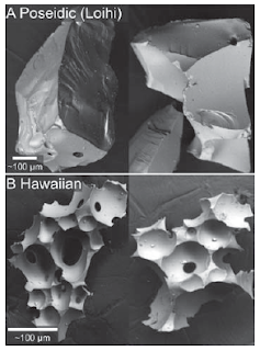
The authors suggest that thermohydraulic fragmentation provides enough initial energy that the overpressured-gas fragmentation can then take over above the level of the vent. This is an interesting idea; if it's true, how much of the fragmentation contribution comes from each process? The smallest particles that Schipper et al. examined  (see Figure 4a-b, Schipper et al. 2010, at left) showed signs of having been produced by thermohydraulic processes (fewer interconnected vesicles, fracture surfaces that weren't bounded by vesicle walls, etc.), but the larger lapilli seemed to have been broken up following expulsion from the vent, which implies that thermohydraulic processes may be limited to the region below the vent. Additionally, there's the question of how representative the samples were; the study retrieved them some years after the eruption took place, and there's no telling how much was carried off by currents or other reworking processes. (Plus it can't be easy to sample something that's 3,000 feet down, since you have to use a submersible to get there. I would have liked to see the authors these as limitations, however.)

The figure at right (Figure 3d, Schipper et al. 2010) provides a good summary of what the authors think is going on: quickly-moving melt exsolves gas and develops vesicles that are unable to coalesce, so they remain spherical and isolated in the melt. When the melt reaches a point somewhere below the vent, it interacts with seawater in thermohydraulic fragmentation (samples represented by white circles in the figure), which then provides the energy to help initiate explosive fragmentation (the dark gray circles, which represent lapilli and bombs in their samples that were not formed by hydromagmatic processes).

The discussion group pretty much all agreed that they liked this paper for both writing style and conclusions, but had some issues with introducing a new bit of terminology to describe explosive eruptions. I have to agree; the term 'Poseidic' does have a basis for distinguishing these eruptions from subaerial ones (based on being underwater, having coupled volatile exsolution, and a particular combination of textures in its tephra), but you could reasonably also call this a 'submarine violent Strombolian' or 'submarine subPlinian' eruption. Still, distinguishing the style as an end-member is a wise choice, given the range of behaviors that volcanoes can exhibit, and the name might just stick. (Loihian is a suggested alternative, although that would come with spelling and pronunciation issues AND would be inaccurate in a few thousand years.)

Schipper, C., White, J., Houghton, B., Shimizu, N., & Stewart, R. (2010). "Poseidic" explosive eruptions at Loihi Seamount, Hawaii Geology, 38 (4), 291-294 DOI: 10.1130/G30351.1

Thursday, April 1, 2010

Amazing natural resources in south-central Utah


Some neat news has come out of the Marysvale Volcanic Field in southwestern Utah (one of my stomping grounds!) about a very recently reactivated hydrothermal system in the Marysvale Canyon. According to an interview with specialist H. McClintock, prospecting in the vicinity of Belknap (five miles north of Marysvale, Utah) has revealed some pretty interesting features that certainly weren't there when I visited last summer.
"We've come across some darn confounding stuff," says McClintock, who was reached for comments earlier today. "We thought that the hydrothermal alteration in the area had pretty much ended, since the Marysvale field has been inactive for the past 20 million years or so, but we've been seeing springs with high levels of hydrogen citrate and saccharose popping up all over the place, not to mention the streams of ethanol. Large drainage sinks have even started to form. We've decided to call the two biggest ones Aquavitae and Burgoo, although we'll have to wait to get the names officially registered."
When asked about potential environmental concerns of the increased hydrothermal activity, McClintock stated that a number of unusual phenomena have been noted in the local flora and fauna. "Local veterinarians have reported an increase in amelogenesis imperfecta, particularly among bulldogs, and there have been complaints that chickens are laying semi-solidified eggs. In addition, one of my crew found an odd tree that seems to be producing small cylindrical fruit consisting primarily of cellulose acetate and Nicotiana tabacum. Folks are getting a mite concerned." McClintock went on to mention that there has been a spate of thefts lately, resulting in a dearth of short handled shovels, axes, saws and picks, and - oddly - socks, forcing his crews to wear the same pair of socks for days on end. "Let me tell you, it's getting pretty ripe around here, although the weather seems to help a bit. Sunny every day, no wind, no snow, no rain - almost paradise. It's not good for keeping folks on the job, though - I keep finding my guys napping in boxcars all day."
McClintock is otherwise fairly excited about the potential for new hydrothermal alteration minerals in the area, since older deposits have been found that contain alunite, jarosite, and gypsum (see the reference below for more information - don't forget to check out the original article!). Gypsum, of course, is essential for building materials like drywall, while alunite is a main source for potash, used in the production of explosives, glass, soap, and soil fertilizers. This discovery also has the potential to repopulate the former mining communities in the area, which have suffered badly since the mines they were built around were abandoned due to lack of production. I'd like to see folks returning to the area, too - it's really beautiful, and well worth the trip if you're ever in that part of Utah.

To close, I'll leave you with another of the photos that was taken along the drive through Marysvale Canyon. The very field area that McClintock is talking about is right in the background there, behind the coconut. (We didn't leave the coconut there, although I'm sure it would have done well with the lemonade springs and cigarette trees.)


References:

"New prospects in the Marysvale Volcanic Field excite economic geologists", The BRCM Hobo, April 1 2010.

Rowley, P.D. et al., 2002, Geology and Mineral Resources of the Marysvale Volcanic Field, Southwestern Utah. Field trip guide, GSA Rocky Mountain Section Meeting, Cedar City, Utah, May 6 2002.