
Monday, June 30, 2008
Traveling again
Sunday, June 22, 2008

Friday, June 20, 2008
How safe is too safe?

That said, when we're teaching it to young 'uns, exactly how stringent should those precautions be? Naturally, if I'm showing a bunch of third- or fourth- or fifth-graders how to identify limestone, I'm going to use vinegar instead of HCl, and make sure they (and I) are wearing those geeky-looking splash goggles because I KNOW they're going to get something in their eyes. Or if I'm out on a field trip with intro geo students, I'm not going to let them swing the hammer or stand near me when I'm trying to knock a hand sample off an outcrop. Common sense. You don't let little kids mess with something that could hurt them, and you don't let older "kids" do something until you're sure they know the proper technique.
One of my projects at the moment is to put together images for a publication where children "doing geoscience" are prominently featured. Because I work for a non-profit, we try to avoid purchasing images from stock photo sources if we already have something public domain or that the organization owns. Free images get used first, and often these have been recycled many times from past years' publications. So we're a little limited in what we can use, and the images can be kind of old. The main point is, we've used the images before, and we've gotten them from places like the USGS, NOAA, NASA, NRCS, USDA, and a hodgepodge of other official letter combinations. And those organizations have seen fit to publish the photos, and in the past, no one's complained about us using them.
Recently, one of the groups to which this particular publication goes (it's a yearly one) has told us that the images don't meet their safety standards, and they can't distribute the publication unless the images are changed or eliminated. Some of their concerns were valid - one person needed to be wearing splash goggles, for instance. But others went completely beyond the realms of reason. If the children were depicted outdoors, the image was unacceptable if they were not wearing long pants, long sleeves, hats and sunglasses (because they might be exposed to UV rays). If a child was collecting water from a stream, they were doing "chemical testing" and needed to be wearing gloves, boots, goggles, a HazMat suit, etc. If the children were anywhere near rocks or dirt and tools, they had to be wearing safety glasses and NOT touching the tools, because something might get in their eyes or they could scratch themselves and get an infection.
The changes, which they requested very late in the publishing process, would have required a great deal more work and money to make, and required us to either stage new photos, or buy them from stock photo sources. Not only that, but some of the same images had been used in previous years in publications that the group has distributed without complaint and without comment from their safety office. But suddenly, this year, the images are not acceptable.
The main point of the publication is to get kids interested in geoscience and get them outside. You know, in the sun and the dirt. I wonder what kind of images would have been acceptable - should we show children rolled in bubble wrap, covered in buckets of sunscreen and locked in a room with walls covered in undyed organic fabric made from non-GM cotton picked by free-range nuns? Sheesh. It's the same attitude that the "disinfect everything" cleaning products companies are espousing: protect the children from every possible danger, because god forbid we should let them develop immunities or common sense. When I was a kid (not very long ago), if I went outside and played in the dirt or climbed a tree or picked up rocks, I got a bath and some band-aids and maybe a little antibiotic cream afterwards, not a disinfecting routine worthy of a cleanroom airlock. If I tripped and fell while I was running, or scraped myself on a tree, or got dirt in my eyes at an excavation (later on in life), I learned from it.
There's a point when the Cover Your Ass attitude has to be balanced out by common sense. Yes, you can be sued if you don't let people know that you should wear goggles when using acid and someone's kid burns their eyeballs after copying your publication. But rejecting an image because there's a faint possibility that someone could interpret it a certain way and potentially do something dumb is just ridiculous. Wow, there's a kid sitting under a tree. If a storm comes along, he could get hit by lightning or a branch could fall on his head or he could be attacked by rabid squirrels or the tree could be cut down by a crazed chainsaw-wielding neighbor, so obviously we can't publish that photo. In fact, all photos of children near trees should be accompanied by a government warning that trees are highly unpredictable natural phenomena, and should be approached with extreme caution.
You can't plan for every idiotic thing that someone could potentially do. Naturally, you shouldn't take unnecessary risks, or let children do obviously stupid or dangerous things. But when you start saying that kids shouldn't be depicted running around in sunlight, or digging in the dirt, or wading in water at the beach, you're just being silly and alarmist. We can't raise a generation of people who have no idea how to handle themselves in the real, dirty, messy, natural world, because they'll just spend their lives inside. And you can't do geoscience from a bubble.
The group ultimately opted not to distribute the publication, which was just fine with us, since it saves us money and the hassle of printing X many thousands of copies. But it's a shame that thousands of teachers and students won't get to see a really great product that encourages them to embrace the geosciences, and get the darn kids outside to do the same.
Wednesday, June 18, 2008
The Accretionary Wedge #10 is up!
Saturday, June 14, 2008
Aesthetic Geology: Thomas "Yellowstone" Moran

Grand Canyon of the Yellowstone, 1872 (Image from Wikipedia)
My first impulse on seeing the latest Accretionary Wedge topic (Aesthetic Geology - Geology and Art) was to look through my books for a favorite volcano painting. There are quite a few, especially from the 19th century, when geology was becoming popular, and they're almost always spectacular (as most images of eruptions are). But because this is the time of year I'm usually out in the field, I decided to concentrate on art that had its roots in the first explorations of the American West. Powell and Dutton's expeditions have always been fascinating to me, but there were others that receive less acclaim, though they were no less important.
 One of these was the 1871 expedition of the U.S. Geological Survey of the Territories, led by geologist Ferdinand V. Hayden. The expedition included, in addition to scientists and frontiersmen, both a photographer and a painter. The painter was Thomas Moran, an English immigrant who had settled in New York City in the 1860s. He eventually became the chief illustrator for Scribner's Monthly, during a time when all the monthlies - Harper's, Atlantic Monthly, and Scribner's - were competing with each other to report on frontier expeditions. In 1871 Scribner's ran a story called "The Wonders of Yellowstone," which Moran was assigned to illustrate.
(Image from American Visionaries: Thomas Moran, National Park Service)
As a result, Moran developed a desire to see Yellowstone for himself, and arranged to join the first government-sponsored survey of Yellowstone - Hayden's 1871 expedition. The expedition departed in the summer of 1871, and over the course of several months Moran produced dozens of watercolor studies and field sketches that would serve as the basis for numerous oil paintings. He collaborated closely with William Henry Jackson, the expedition photographer, and many of his watercolors and sketches are mirrored in Jackson's photographs of the expedition.


Moran's field sketches, and the paintings he created from them, were the first color images of Yellowstone ever seen in the East, and did much to stimulate public interest in westward expansion. Soon after the expedition's return, Ferdinand Hayden and others began promoting the idea that Yellowstone should be protected and preserved as a national park. Because no member of Congress had seen Yellowstone, Hayden and his colleagues brought Moran's watercolors, along with the photographs taken by William Henry Jackson, to Capitol Hill.

Their images were key in convincing the Congressional Committee assigned to the matter to establish Yellowstone as the first national park in March 1872, only seven months after the work on the Hayden Survey ended. Congress later purchased two of the oil paintings that Moran created from his sketches to hang in the U.S. Capitol: The Grand Canyon of the Yellowstone (1872) and The Chasm of the Colorado (1873). The powerful images in Moran's paintings, of Yellowstone and elsewhere in the West, "fired the imagination and helped inspire Congress to establish the National Park System in 1916" (NPS).
Thomas Moran may be considered a member of the Hudson River School of painting, but his colorful landscapes and romantic depictions of lands in the West stepped far beyond the boundaries of many of his contemporaries. Because of his work's influence on Congress, he has been called the "Father of the National Park System", and Corps of Engineers Captain Hiram M. Chittenden wrote that Moran's paintings (and Jackson's photographs) "did a work which no other agency could do and doubtless convinced everyone who saw them that the regions where such wonders existed should be preserved to the people forever."
"...Yellowstone retains its hold upon my imagination with a vividness of of yesterday...The impression then made upon me by the stupendous and remarkable manifestations of nature's forces will remain with me as long as memory lasts." -- Thomas MoranThomas Moran's work impresses me not only for its beauty, but because he, a man who had never ridden a horse and camped only once in his life, took it upon himself to travel to a place almost wholly unexplored in order to share its wonders with his adopted country. I've not yet visited Yellowstone, but I hope that when I do, I'll be able to see it with the same reverent and unjaded vision that Moran brought to his art.
References:
Thomas Moran (National Gallery of Art)
American Visionaries: Thomas Moran (National Park Service)
Yellowstone Digital Slide File: Moran works and other art (National Park Service)
Thomas Moran and the American Landscape (Joshua Johns, University of Virginia)
Friday, June 13, 2008
Everything I need to know in life, I learned on geo field trips
Maybe in a few weeks. But in the meantime, because it's Friday and it's fun to make lists, I thought I'd go through some of the useful things I've learned in the field - mostly through personal experience or helping bandage up someone else who didn't learn them fast enough. (Fortunately none of them required hospitalization, but considering that I'll be working with active Guatemalan volcanoes next year, it's only a matter of time :)
- Scotch makes a pretty good anesthetic when you're picking volcanic glass out of your hands. (Taken orally, of course.)
- If your professor is capable of running marathons, don't try to beat him at capture-the-flag.
- If a moose wants to eat your Hint-of-Lime Doritos, let it.
- Tarantulas can move pretty damn fast if they want to.
- That cute, innocent looking cactus is perfectly capable of putting a spine through your boot into your big toe.
- Cactus tastes like kiwi fruit.
- Don't listen to your adviser if he says "You should ford the river there, it looks pretty shallow."
- Spam should only be eaten in an emergency.
- Store-brand Spam tastes better than name-brand.
- Bits of ash fall deposits explode beautifully on impact.
- Nighttime swimming in sea-urchin infested waters is bad for your feet.
- Duplex cookies are second only to fresh blueberry pie as the ultimate field trip dessert.
- Tuna fish and Duplex cookies do not mix.
- Don't let inebriated underclassmen run off with the satellite phone, even if it does have unlimited minutes. (Especially if it has unlimited minutes.)
- Sitting directly on top of a hot spring usually results in A) burns in inconvenient places or B) bruises from people trying to shove you off the source of warm water.
- In some places, it's good to be a wine snob, because it's cheaper than the beer.
- It is possible to get excellent phone reception while standing on top of an erupting volcano.
- Field clothing is not really appropriate for traversing the lobby of the Bellagio.
- It's not really an illegal border crossing if you're only there for a few minutes.
- Trout is excellent breakfast food.
- Real men don't wear "pink" - they wear "desert rose".
Wednesday, June 11, 2008
And geology is...

Tuesday, June 10, 2008
Changes
A note to these people: I don't write this blog so you can waste my time arguing about what I write. There are other blogs out there whose owners will be more than happy to do that. If you're simply trolling for a fight, it's my prerogative to delete your comment. It's my blog. If you have a problem with that, get your own blog or go away.
Guess I should remember the warning of more experienced denizens of the blogosphere and internet forums: Don't Feed The Trolls.

Monday, June 9, 2008
Geoarchaeology: Footprints in ash and the first people in North America

The quarry where the footprints were discovered in 2003 is located in Mexico's
(Image from the NatGeo website, credited to Silvia Gonzalez, Liverpool John Moores University, United Kingdom.)
There seems to be some confusion between various articles about the ash itself - in another 2005 article, the ash is described as being 1.3 M.Y.O. - far too old for anyone to have created the footprints in it while it was still fresh. The new NatGeo article raises this question, but says that "dating the ash is complicated by the fact that an eruption occurred underwater, said Silvia Gonzalez of Liverpool John Moores University, in the United Kingdom." What's strange is that in the Bristol article, the explanation is this:
"The footprints were preserved as trace fossils in volcanic ash along what was once the shoreline of an ancient volcanic lake. Climate variations and the eruption of the Cerro Toluquilla volcano caused lake levels to rise and fall, exposing the Xalnene volcanic ash layer. Early Americans walked across this new shoreline, leaving behind footprints that soon became covered in more ash and lake sediments. The trails became submerged when the water levels rose again, preserving the footprints."Both quotes were made by Dr. Gonzales, which is somewhat confusing. I don't quite understand why the discrepancy exists, but I suspect that at least one of the articles has fallen victim to some bad editing.
Anyway, the short of all this editing mess is that the 1.3 Ma age is a combination of the age of the ash-producing magma and bedrock pulverized by the eruption. The new study used "optically stimulated luminescence" to determine when the hardened ash was last exposed to sunlight (or volcanic heat), and came up with an age of 40,000 years. Sediment below the ash layer was dated to 70-100,000 years, and above it to 9-40,000 years. This means that the footprints should be at least 40,000 years old, and possibly more, since the ash layer could have sat around for a good long time before being buried by the younger sediments.
I find all this pretty exciting because it has to do with an ongoing (but hopefully dying) debate in the archaeological community about when the first humans arrived in North America. It was a favorite topic of the professor who taught my Intro to Archaeology class, and it's been going on for a good long time now - since the late 1960s, and there are still people arguing about it, although I think the Clovis holdouts pretty much just clinging to dogma by now. "Clovis First" holds that the Clovis people, a Paleoindian culture that first appears in the archaeological record about 13,000 years ago, were the first migrants to the North American continent. The first Clovis points (spear and arrowheads), which have a distinctive "flute" down the center of the point, were discovered in New Mexico in the late 1930s, and have since been found all over North America (and even in parts of Central and northern South America).
For a long time, it was accepted that the Clovis people were the first to show up. Then, in the 1970s, James Adavasio discovered material at the Meadowcroft Rockshelter near Avella, Pennsylvania, that was radiocarbon dated to 16-19 Ka. In 2004, a site in South Carolina called Topper produced charcoal fragments that were radiocarbon dated to 50 Ka, and were interlayered with what appeared to be worked stone tools. There were all sorts of disputes about the accuracy of the carbon dating - some people claimed that the site was contaminated with older material, or that the dating was done incorrectly, or that the charcoal had resulted from natural causes (wildfires or lightning strikes), or that the stone wasn't worked but had been chipped by natural forces.
Other sites (like Monte Verde in Chile, dated to 14.5 Ka) have been discovered that pretty much negate the Clovis First theory, as they change the timing of migrations to North America over the Bering land bridge. (The Clovis people couldn't have been the first over the bridge if the Monte Verde culture, which is more than a thousand years older, made it all the way to South America before the Clovis people did. The Monte Verde research also sparked the theory that the migrations were mainly along coastal waterways, and not limited to land, as had been previously thought.)
The whole thing is a great example of how theories evolve - and it's neat that I can finally use something I picked up in my anthropology minor! (I also think it's pretty cool that the evidence for really old cultures in the Americas is preserved in volcanic ash, but that's just me.)
Thursday, June 5, 2008
Stop! In the name of the carbonate!
I just came across this news item, which discusses a proposal a new method for slowing and/or diverting a lava flow. The original article is titled "How to stop or slow down lava flows", by R.D. Schuiling in the International Journal of Global Environmental Issues, 2008, vol. 8, p. 282-285. I can't access the journal itself, but the summary goes like this:
 divert lava flows from closing off the entrance to their harbor in the eruption of Eldfell in 1973. (I seem to remember there were some questions as to whether the flows were diverted because the method actually worked, or if there was some change in the eruption that slowed down the effusion rate anyway - I'll have to check on that.) And in 1935, 1940 and 1942, Mauna Loa lava flows threatening Hilo were bombed in an attempt to keep them from reaching the city (with no significant effects, although studies since then have suggested that better targeted aerial bombing "has a substantial probability of success for diversion of lava"[Lockwood and Torgerson, 1980]).
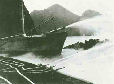
(Above, USGS image of ships pumping seawater onto the forward margin of the Heimaey lava flow, Photograph courtesy of Sigurgeir Jónasson, March 1973. To right, B-18s over Mauna Loa eruption, April 1940, from the Hawaii Aviation website.)
And, of course, there's always the Jersey barrier solution employed by Tommy Lee Jones in Volcano.
While I'm sure that the chemistry behind the new idea is sound, I have questions about the physical aspects of the situation. A lava flow, even a really fluid one, has a lot of mass, and the source of the flow is constantly adding more. A flow doesn't stop unless its source stops producing lava. It can sometimes be diverted (naturally or not), but more often than not it's simply going to go around or over an obstacle, and keep on moving in the same direction as before. Then you have a whole new set of problems: Where is the diverted lava going to go? How long will the barrier last, and if it fails, are you going to have lava going in multiple directions? This is the very reason that Volcano's Jersey barrier solution was unrealistic - even if they could hold back the lava in the first place, the lava had to go somewhere, and with that kind of force, the barriers wouldn't last very long anyway.
Knowing the capability of lava flows for pretty much bulldozing over anything in their way, I don't think that building a limestone wall in the way of one would be very effective. I could be wrong, though; basaltic lava flows on Hawaii become channelized all the time by their own debris, and I suppose if you were able to dump enough limestone on one in strategic locations, you might be able to divert it. I do think, despite being skeptical of the idea, that it would certainly be really cool if it did work. Not to mention that it might actually be affordable, since limestone is common in nature and used widely for construction. (More affordable than bombing, anyway.)
Come to think of it, Jersey barriers are made out of concrete. Concrete contains cement, and cement is made partially out of limestone. Hmm. Maybe TLJ had something going there...
References:
"Volcano taming: Could geochemistry save lives during volcanic eruptions?" (Eurekalert)
Schuiling, R.D., 2008, How to stop or slow down lava flows: Int. J. Global Environmental Issues, 2008, vol.8, p.282-285 (Link to abstract)
Man Against the Volcano: The Eruption on Heimaey, Vestmannaeyjar, Iceland (USGS Publication)
Lava-Cooling Operations During the 1973 Eruption of Eldfell Volcano,
Heimaey, Vestmannaeyjar, Iceland : U.S. Geological Survey Open-File Report 97-724
Lockwood, J.P. and Torgerson, F.A., 1980, Diversion of lava flows by aerial bombing — lessons from Mauna Loa volcano, Hawaii: Bulletin of Volcanology, vol. 43, no. 4, p.727-741. (Link to abstract)
I'm kind of skeptical about this. Methods of stopping or diverting lava flows have been tried for centuries, with varying success. The Neapolitans called on their patron San Gennaro to turn away lava flows produced in the 1631 eruption of Mount Vesuvius (although one would think that the flows "spared" Naples more because their supply was cut off than because of the intervention of a 4th-century martyr). The Icelandic town of Heimaey was able to use seawater cannons to partially"Schuiling believes a geochemical approach might be effective in controlling lava flows across the globe. He explains that certain common rocks, namely dolomite, or limestone, will react strongly with hot lava at 1100-1200 Celsius. The chemical reaction that ensues is highly endothermic, which means it requires heat, and this would be supplied by the hot lava.
"The decarbonation of limestone by the hot lava will therefore rapidly cool the volcanic outpourings, making it far more viscous and quicker to solidify. The reaction will leave behind solid calcium and magnesium oxide mixtures - pyroxenes or melilites depending on the specific type of lava. The process would also release some carbon dioxide.
"He suggests that large chunks of dolomite or limestone blocks could be thrown on to lava from the sides, or from above by helicopters or airplanes, or even by an aerial cable system passing over the flow. An alternative approach might be to quickly build a wall of limestone blocks in the path of the advancing lava flow. In places where a future lava flow would cause great material damage, such walls could even be constructed as a forward defense before a new eruption." (Eurekalert)
divert lava flows from closing off the entrance to their harbor in the eruption of Eldfell in 1973. (I seem to remember there were some questions as to whether the flows were diverted because the method actually worked, or if there was some change in the eruption that slowed down the effusion rate anyway - I'll have to check on that.) And in 1935, 1940 and 1942, Mauna Loa lava flows threatening Hilo were bombed in an attempt to keep them from reaching the city (with no significant effects, although studies since then have suggested that better targeted aerial bombing "has a substantial probability of success for diversion of lava"[Lockwood and Torgerson, 1980]). (Above, USGS image of ships pumping seawater onto the forward margin of the Heimaey lava flow, Photograph courtesy of Sigurgeir Jónasson, March 1973. To right, B-18s over Mauna Loa eruption, April 1940, from the Hawaii Aviation website.)
And, of course, there's always the Jersey barrier solution employed by Tommy Lee Jones in Volcano.
While I'm sure that the chemistry behind the new idea is sound, I have questions about the physical aspects of the situation. A lava flow, even a really fluid one, has a lot of mass, and the source of the flow is constantly adding more. A flow doesn't stop unless its source stops producing lava. It can sometimes be diverted (naturally or not), but more often than not it's simply going to go around or over an obstacle, and keep on moving in the same direction as before. Then you have a whole new set of problems: Where is the diverted lava going to go? How long will the barrier last, and if it fails, are you going to have lava going in multiple directions? This is the very reason that Volcano's Jersey barrier solution was unrealistic - even if they could hold back the lava in the first place, the lava had to go somewhere, and with that kind of force, the barriers wouldn't last very long anyway.
Knowing the capability of lava flows for pretty much bulldozing over anything in their way, I don't think that building a limestone wall in the way of one would be very effective. I could be wrong, though; basaltic lava flows on Hawaii become channelized all the time by their own debris, and I suppose if you were able to dump enough limestone on one in strategic locations, you might be able to divert it. I do think, despite being skeptical of the idea, that it would certainly be really cool if it did work. Not to mention that it might actually be affordable, since limestone is common in nature and used widely for construction. (More affordable than bombing, anyway.)
Come to think of it, Jersey barriers are made out of concrete. Concrete contains cement, and cement is made partially out of limestone. Hmm. Maybe TLJ had something going there...
References:
"Volcano taming: Could geochemistry save lives during volcanic eruptions?" (Eurekalert)
Schuiling, R.D., 2008, How to stop or slow down lava flows: Int. J. Global Environmental Issues, 2008, vol.8, p.282-285 (Link to abstract)
Man Against the Volcano: The Eruption on Heimaey, Vestmannaeyjar, Iceland (USGS Publication)
Lava-Cooling Operations During the 1973 Eruption of Eldfell Volcano,
Heimaey, Vestmannaeyjar, Iceland : U.S. Geological Survey Open-File Report 97-724
Lockwood, J.P. and Torgerson, F.A., 1980, Diversion of lava flows by aerial bombing — lessons from Mauna Loa volcano, Hawaii: Bulletin of Volcanology, vol. 43, no. 4, p.727-741. (Link to abstract)
Wednesday, June 4, 2008
Suburban excursions
I live in a pretty generic suburban area, but much of the housing in my neighborhood was built in the 50s and 60s, and it seems that they weren't so keen on destroying all of the natural environment back then. As a result, there are a lot of wooded areas and a number of small streams that cut through Coastal Plain sediments and drain into the Potomac. A geologic map of the area calls the deposits "Qte: Low-level fluvial and estuarine deposits (Pleistocene)." Mainly, it's a lot of sand with pebble-to-cobble sized clasts and lots of of iron oxide chunks - overlain, naturally, by every polymorph of poison ivy conceived of by nature. It's an area I'm familiar with, having spent a great deal of time there when I was young, getting mucky and probably exposing myself to any number of diseases and bacteria (I didn't actually go IN the stream, but even with wading boots, it's hard to avoid getting a little wet. Hooray for rubbing alcohol and soap.)
The streams themselves are supposedly spring-fed, and there are a few roads and subdivisions with "Springs" in the name. I suspect more water comes from runoff these days, since there are a lot of paved surfaces in the area, but I can vouch for the existence of the springs - one part of my yard and the sidewalk adjacent are constantly wet, no matter what the weather has been like, and none of the drains in our house connect to the sewers in that area. Wet enough, in fact, that's it's created a great example of differential erosion in the concrete curb where the water drains to the street.
Anyway, back to the rocks. Here are some of the clasts I picked up:
Antietam metasandstone: An old friend, and one I was expecting to find in abundance (which I did). Very distinctive Skolithos trace fossils (worm burrows), which make it pretty easy to spot. This is a Chilhowee Group rock
 A closeup of one of the tubes.
Sandstone with cross-stratification: Lots of this, surprisingly. The cross-stratification ranged from mm to cm-scale layers (in the largest cobble I picked up). I'm betting Chilhowee Group again, possibly Weverton (braided stream deposits) or another part of the Antietam.


 Chert: Again, unsurprising; this stuff shows up a lot in stream beds. I thought at first it might be micritic limestone, but it won't scratch or fizz, so chert's the verdict. It probably came from a carbonate unit like the Lincolnshire Formation (middle Ordovician cherty limestone).


Anthracite coal: No photos of this, but I'm sure everyone can guess what it looks like. I was a bit surprised to find it, as this particular stream doesn't run anywhere near railroad tracks, which is usually where I find stray coal in my area. I have doubts that it would have survived the trip from western Virginia to the Coastal Plain, so I don't think it arrived here naturally. Perhaps it was dumped or washed in from someone's yard - the land around my house used to be part of a large farm, so maybe it's historic coal.
I really want to show off the cross-bedding in the large cobble I collected, but I haven't had a chance to clean it properly just yet. I've also found a few other samples that I'm not completely sure of, but again, haven't had time to sit down with the handlens and camera, so they'll have to wait until the weekend.
Some good resources for Virginia geology:
USGS Geolex Database: This is a great website - it allows you to look up recognized geologic units by age, name, location (down to the county level), rock type, even by author citation. Units are displayed with alternate names, "areal extent", type localities, subunits, and a history of the names and descriptions that have been applied to the unit, even back into the 19th century, with the authors and publications they're found in.
Geology of Virginia (College of William & Mary): A very good basic overview of Virginia geology, with generalized province and geologic maps to download, and a selection of outcrop and sample photos.
Geological Evolution of Virginia and the Mid-Atlantic Region (JMU): Oddly organized, in my opinion, but useful for quick reference.
Virginia Department of Mines, Minerals and Energy, Division of Mineral Resources: Archived issues of the Virginia Minerals newsletter, some open-file reports, and a source for info on diamonds in Virginia.
Monday, June 2, 2008
Job Opportunity
"Outreach Assistant. This full-time entry-level position reports to the Manager of Outreach. Duties include writing and editing, preparing electronic documents and updating Web pages, and various clerical functions associated with development of materials for the organization's national earth science public awareness campaign, as well as earth science curriculum products and professional development services."I end up working on more than this, most days, because the staff here love to have someone available with background knowledge of geology; I'm currently producing a geology-oriented poster series and helping with research for an environmental science textbook. The job is in the Northern Virginia area, which is affordable if you're willing to share living space or have a spouse/S.O. who's contributing a salary. (The commuting is icky, but there's really no way to avoid it.) On the plus side, you're close to DC, within a few hours of Richmond, Charlottesville and the Shenandoahs, Annapolis, and Baltimore.
The ideal candidate would be someone who can commit a year or more to the job, has at least an undergraduate degree in geology or environmental science, and either lives in the DC metro area or is willing and able to move here. An interest in earth science education is also a plus, but not required.
If any of you know of anybody qualified, let me know! They can contact me with the email listed on the blog, and we'll go from there.
Sunday, June 1, 2008

Subscribe to:
Posts (Atom)


