
I've decided to run the 200th Wo(G)E on Earth Day, since it's also the 40th anniversary of the first Earth Day. What better way to take advantage of the date than to use Wo(G)E to highlight the beauty and the geology we can find on Earth?
So in this edition, not only are you going to see a lovely scene as revealed by Google Earth...you're going to see four, in honor of the four decades of celebrating Earth Day. (Yes, I'm evil. Hahahahaha!) And they're not just pretty pictures, but also locations that are geologically and environmentally significant. So here's the deal: Find the coordinates for each location and take a stab at describing why it's geologically significant. First person to come up with accurate locations and a reasonable explanation for each gets to host the next edition of WoGE; if you don't have a blog, you're welcome to choose a location and I'll be happy to post it for you.
A hint or two: Pay attention to the scalebars; altitudes were varied to make the images more aesthetically pleasing. No two features are on the same continent, and a few aren't on continents at all. There's not any particular underlying theme here - mostly I've just tried to choose remote locations. Click on the images to view them full-size.
Because I've made this Wo(G)E a bit more time-consuming by adding multiple locations, I'm not invoking the Schott Rule. First one to four wins!


PS - I get a lot of spam, so my comments are moderated. Don't worry if your answer doesn't show up right away - I receive them all in the order that they were submitted, so your position in the race is preserved. Have fun!


6 comments:
Two down... These are tough!
#1 - 24°27'23.19"N, 4°19'20.31"W
Aeolian Dunes (Mali Sahara); climate warming
#2 - 63°53'40.98"N, 17°0'26.74"W
Grímsvötn/Vatnajökull jökulhlaup outflow channel (Iceland); ridge/hotspot volcanism
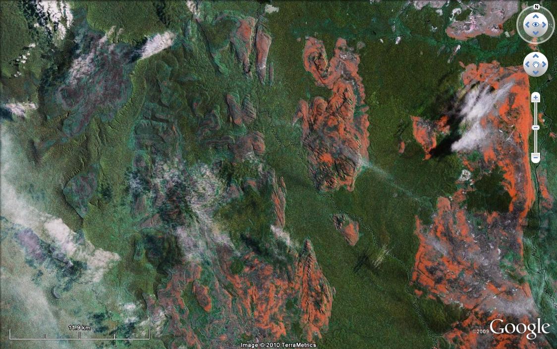
#3 - 67°15'24.98"N, 70°39'22.03"E
Thermokarst lakes (Russia); climate warming
#4 - 0°37'46.51"N, 72°45'19.16"W
Roraima Formation Western Limit (quartzite, sandstone, Macarena Uplift, Colombia); tepui ecology
Congratulations - excellent job! Hope you won't mind if I add a bit to the explanations - these are all unique locations, and you shouldn't have to work any harder on them!
The location in Mali is a good example of a location that used to have a much wetter climate (the southern Sahara used to experience monsoons until about 5,000 years ago), and the area was also the site of a 10th century salt trade route.
The outflow channel in Iceland is also known as the river Skeiðará, and it is indeed another site at risk for jökulhlaups.
The western Siberia peatlands are one of the planet's biggest carbon sinks, but as they warm they'll release increasing amounts of dissolved organic carbon (DOC) to the Arctic Ocean. (Here's the research that led me to choose this location: https://www.clarku.edu/departments/geography/pdfs/Frey_Amplified%20Carbon%20Release.pdf)
And tepui ecology refers to the isolation of plant and animal species on these table mountains. Arthur Conan Doyle based his Lost World around the idea that dinosaurs might still survive on these isolated mountaintops.
JimmyJames, WoGE #201 is yours - if you have somewhere to post it, please leave the link here; if not, let me know and I'll be happy to post it for you.
Good searching!
Thanks Jessica, for the fascinating challenge and the accompanying explanations.
I appreciate your offer to host the next contest since I don't blog. I have a WoGE#201 location and image arranged that I'll post at a public site for you to access. Please standby for the link to that as I am setting something convenient up.
Jessica, would you please be kind enough to blog post the following quoted text as well as the 3 downloadable images found at the 'My Web Page' link on my Blogger profile.
"This is my first win of Where on Google Earth and I'm honoured to be amongst the folks that participate in this contest. I should admit right away that I am not a geologist (nor indeed a blogger) but I have tried to make the WoGE #201 a challenging puzzle.
This edition of WoGE#201 reveals yet another attractive example of folded sedimentary strata.
As ever, to win WoGE find the Longitude and Latitude of the image, identify the country / area and describe the geological significance of the feature, then post this information in the Comments section below. The first one to post the correct information will go on to host the next edition of WoGE.
With respect, I'm invoking the (Ron) Shott rule: "Previous winners must wait at least one hour for each win that they have before posting a solution - other comments would be okay".
Good luck to all of you! And a heartfelt thanks to 'Tuff Cookie' for hosting my post!
To compensate for the low res Google imagery, I have supplemented it with some higher resolution aerial orthophotos for your viewing pleasure."
Thanks for the post! I'll keep an eye on the comments and publish as soon as I notice them. Let me know when someone comes up with the right answer!
Post a Comment