Thursday, February 26, 2009

You need to go here! (and here, and here....Accretionary Wedge #16)

In this month's Accretionary Wedge (which I am late for, having been distracted by seismic modeling in MATLAB yet again...), Geotripper asks:

What are the places and events that you think should all geologists should see and experience before they die? What are the places you know and love that best exemplify geological principles and processes?

Now, I write about volcanoes a lot. But I wouldn't write about them if I didn't think they were some of the most exciting geologic phenomena ever. I've written before how some parts of geology are a bit like detective work - we take clues left over from events unseen and try to piece together a little bit of the Earth's history. At volcanoes, we do the same thing - but we get to do it in real time. The fact that you can see a major geologic process at work in a human timescale is just amazing to me. (This also applies to things like mass movements and floods and earthquakes as well.)

So my recommendation for all geologists (and I know this one was on the list) is to visit a volcano at least once in your life. Volcanoes are part of the reason the Earth has an atmosphere, and land for us to walk on, and water to drink. They make new land all the time. They're the Earth's construction workers who occasionally dabble in demolition.

I've been fortunate enough to visit volcanoes in several countries, and I'm going to add a few more to the list before the year is out. Here are some things that I've done so far, and that I recommend that anyone do:

(Kilauea ocean entry flow field, Hawaii)

Get up close and personal with some lava. Experience what it's like to stick your face into a blast furnace. Do some collecting - you'll be able to say that you know exactly when your rock was formed!

(SP Mountain, Arizona)

Ski down a scoria cone. It's twice as much fun as getting to the top, if you're careful not to rip up your hands doing it. Be sure to clean out your boots afterward, though.

(Kilauea Caldera)

Inhale the not-so-delicate aroma of a degassing fumarole. (Don't stick your face, hands, or feet into it, though. Instant blisters and acid fumes are not good for you.)

(Volcan Poas, Costa Rica)

Hike (or drive) to the top of a stratovolcano and experience the lovely localized weather systems. Cheering on appearance of the summit caldera is definitely recommended.

(Fish Lake Plateau, Utah)

Take the time to appreciate some old volcanics. Throw lithified ash at something - it explodes quite nicely.

(1991 eruption of Mount Pinatubo, Philippines)

And, as cool as a pyroclastic flow looks from a distance, don't do this.

Wednesday, February 25, 2009

A letter to Gov. Bobby Jindal:

To say that I was shocked, appalled and dismayed on hearing the "volcano monitoring" comment in your speech following President Obama's address to Congress would be a massive understatement.

You, and anyone who thought that including that comment in the Republican rebuttal was a good idea, are guilty of the dangerous and pervasive attitude of willful ignorance about science that has sadly pervaded the government of this country in the past eight years. It is extremely frightening that you, the governor of a state that recently experienced a major natural disaster, think that the paltry amounts spent on volcano monitoring in our country are a waste of money.

It is simply appalling that you cannot be bothered to educate yourself about some of the most basic knowledge that geologic science has to offer. Volcanoes are extremely dangerous and costly phenomena. The people of states like Hawaii, Alaska, Washington, Oregon, and California, depend on volcano monitoring to preserve their lives and livelihoods.

Perhaps you think that $140 million is too high a price to pay for the thousands of lives that were saved by volcano monitoring during the 1980 Mount St. Helens eruption? Or the millions of dollars in commerce and countless lives that are preserved by monitoring Alaskan volcanoes which lie in the flight paths of major shipping and passenger airlines? Are you the least bit aware that a major volcanic eruption could produce enough ash to reach even Louisiana, disrupting or shutting down air traffic for thousands of miles and crippling our country's airline industry? Or that an eruption or collapse of Mount Rainier could kill or displace tens of thousands of people with ash falls, pyroclastic flows and mudflows?

Lack of monitoring and communication caused the needless deaths of 23,000 people in the 1985 eruption of Nevado Del Ruiz volcano in Columbia. Would you prefer that we, a technologically rich country with the expertise and resources to prevent such a disaster, should eliminate the very monitoring programs that enable us to do so just because politicians like you can't be troubled to learn about why they're so important?

Your attitude toward volcano monitoring as a representative of our country's government is irresponsible and potentially deadly. If you suggest that we should discontinue volcano monitoring simply because you refuse to make the effort to understand it, then you are making yourself personally accountable for the lives, property and money that will be lost in volcanic eruptions. I am sure you will be happy to explain to the American citizens who will suffer from your recommendations why your state deserves funding to monitor and mitigate the hazards associated with flooding and hurricanes, but their homes and lives are unworthy of protection.

$140 million is a small price to pay to prevent the millions, possibly billions of dollars in property and commerce and tens of thousands of lives that will be in danger in the event of a volcanic eruption in the United States. Even now, Redoubt volcano in Alaska is showing signs that it may soon erupt, and the effects of such an eruption will not only impact the people of Alaska, they will affect the oil, fishing, and airline industries as well. Saying that we should discontinue volcano monitoring in the midst of a potential volcanic crisis is stupid, irresponsible and ignorant.

Blind adherence to politics is one of the reasons that America is in the middle of an economic crisis today. Don't make it worse by adding natural disasters to the mix.

You have, in your callous, ill-educated and ill-considered words, grievously insulted the men and women of the geologic community who have dedicated their lives to protecting others from natural hazards such as volcanoes. They do their work for the sake of ordinary Americans who, on their own, have no way of understanding or preparing for volcanic eruptions. You show enormous disrespect for the scientists who safeguard the safety of those who live in the shadow of active volcanoes.

I am truly frightened by anyone who claims to represent American citizens in public office by making such irresponsible and, frankly, stupid statements about scientific endeavors that he has made no effort to understand. You, and anyone who supports you in this statement, are unworthy of being responsible for the safety of the American public, and I hope that those in charge of our nation's budget will rightly ignore your hideously bad ideas.


Update: There are a lot of people that feel just as strongly about this as I do.

Maria Brumm at Green Gabbro (and again)
Garry Hayes at Geotripper
Ralph Harrington at The Volcanism Blog
Eric at The Dynamic Earth
Phil Plait at The Bad Astronomy Blog
Dave Schumaker at Geology News (and again)
Anna at Adventures in the world of Geology
Andrew Alden at About Geology
Chris Rowan at Highly Allochthonous
Short Geologist at Accidental Remediation

Saturday, February 21, 2009

Using Google Earth to visualize volcanic and seismic activity

I haven't been posting much lately (teaching labs and trying to wrap my head around volcano seismology is eating up my free time), but I have been trying to keep up with new developments. One really neat one is the release of the newest Google Earth and the Oceans layer. My last two labs have been oceanography and waves/tides/currents, so I've been leaning heavily on Google Earth to help my students visualize things. And it works! They're actually engaged, especially since they get to navigate around instead of just watching me give a lecture.

The Oceans layer comes with a lot of other sublayers, including one from National Geographic about plate tectonics, earthquakes and volcanoes. Being a geology geek, I already have several volcano/earthquake layers from the Smithsonian, USGS, etc. So, I thought it might be interesting to compare the old and new offerings.

Here's the first - the Smithsonian Global Volcanism Program's catalog of Holocene volcanoes.

I like this layer because clicking on a volcano pops up the text of the GVP webpage on that volcano, complete with photo and links. What I don't like about the layer is that this is all it does - nothing about plate tectonics, nothing about older volcanoes. You can see where the volcanoes are, but not (at first glance) why. Also, I'd opt for a snazzier symbol; that little X-and-box thing is efficient, but kind of boring.

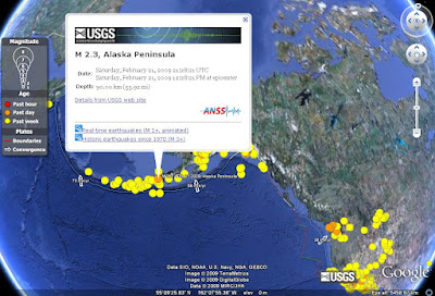
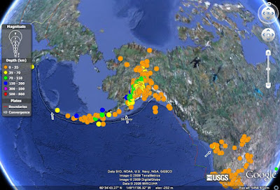
Then there's the USGS layers for earthquakes. (They don't seem to have a volcanoes layer, but they do have an interactive map of recent activity here). One EQ layer shows earthquakes by age (i.e., in the past hour, day, week, etc.), and the other by depth. I like the clean look of these, the small legend, and the information that pops up for each earthquake, complete with links to the USGS online record and

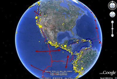
The most recent earthquakes are shown in red (hours ago), days-old earthquakes in orange, and months-old earthquakes in yellow.

Here the shallower earthquakes are in red and orange, and the deepest are in blues and purples.

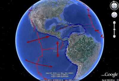
I like these because the symbols are easy to read, the legend is simple, and there's information about tectonic plate motions (including rates of movement) and boundary locations. The layers also updates themselves each time you open up Google Earth - very useful if you're teaching a class on plate tectonics, and want your students to keep track of earthquake activity in a particular area. You can even highlight specific types of plate boundaries, which are have their own separate sublayers.

The USGS has one more layer of historical earthquakes, with M3 in the past 90 days, M4 in the past year, and so on up to M9 (since 1970 - only one of these, the 2004 Sumatra earthquake).

No legend or drawn-out plate boundaries on this one, but a wealth of information and popups for each earthquake. It's especially good for highlighting plate boundaries using seismic activity.

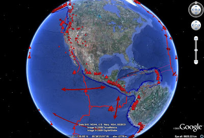
Finally there's the new National Geographic plate tectonics layer. They went all out on this one - sublayers for plate boundaries, volcanoes, hot spots, earthquakes, plate motions...the whole shebang. It's actually quite crowded at first. Unfortunately, to download it you have to turn on the main National Geographic sublayer of the Oceans layer, search for the NG symbol in the middle of the Pacific Ocean, and click to download the plate tectonics bit. This is a major drawback for the NG information, and in the future I hope they list their information somewhere instead of making you hunt for it on the globe.

One thing that I severely dislike about this layer is the legend. It's far too large and covers up a significant chunk of the globe. It's not adjustable, either, so unless you immediately memorize all the symbology, you have to keep turning it on and off. The sheer volume of information shown is also distracting - it's better to break it down.

This one shows the plate boundary locations and types, and relative plate motions. Unlike the USGS layer, however, there's no information about rates of movement.

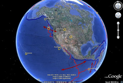
This view shows some of the "Selected Hot Spots". I'm a little iffy on whether all of the locations this layer shows are properly considered hot spots - there's a lot of argument about these phenomena anyway. The bad thing about this layer is that beside displaying the names, there's no pop-up info about these locations, nor is there any explanation of what a hot spot is.

This view is showing the "Notable earthquakes since 1900" and "Quakes since 1900 greater than 6.5 magnitude" layers. Again, no information about the individual events, other than marking their location. I suppose it's useful for highlighting areas of high seismic activity, but it would be much better if there were at least magnitudes and dates listed for each event, so someone could look them up elsewhere.

And, finally, the volcanoes - small triangles are Holocene eruptions, and large ones are eruptions since 1900. Yet again, there's no further information - this is where the Smithsonian layer outstrips the National Geographic one, despite its simplicity.

So what's the final verdict? Use all of them! I'd reserve the National Geographic layers for general overview - showing the locations of plate boundaries, eruptions and earthquakes, for example - but use the USGS and Smithsonian layers for more in-depth examinations. The USGS layer is especially good for teaching seismology and plate tectonics, since it gives information on plate motions and individual seismic events - and links it all to the USGS database.

I'm looking forward to reviewing new layers as I find them, and hopefully I'll get a chance to use them in my teaching.

Thursday, February 12, 2009

Darwin is for volcanologists too!

Happy Birthday to Charles Darwin, who, in addition to his invaluable contributions to evolutionary science, also gave us a few insights on the geology of the Galapagos islands. Swimming iguanas and giant tortoises are cool too, but hey, those islands are volcanic! To celebrate Darwin Day, here are some Galapagos photos and excerpts from The Voyage of the Beagle.

"September 15th - This archipelago consists of ten principal islands, of which five exceed the others in size. They are situated under the Equator, and between five and six hundred miles westward of the coast of America. They are all formed of volcanic rocks; a few fragments of granite curiously glazed and altered by the heat, can hardly be considered as an exception. Some of the craters, surmounting the larger islands, are of immense size, and they rise to a height of between three and four thousand feet. Their flanks are studded by innumerable smaller orifices. I scarcely hesitate to affirm, that there must be in the whole archipelago at least two thousand craters. These consist either of lava or scoriae, or of finely-stratified, sandstone-like tuff. Most of the latter are beautifully symmetrical; they owe their origin to eruptions of volcanic mud without any lava: it is a remarkable circumstance that every one of the twenty-eight tuff-craters which were examined, had their southern sides wither much lower than the other sides, or quite broken down and removed. As all these craters apparently have been formed when standing in the sea, and as the waves from the trade wind and the swell from the open Pacific here unite their forces on the southern coasts of all the islands, this singular uniformity in the broken state of the craters, composed of the soft and yielding tuff, is easily explained."
© MichaĆ«l Lejeune, CC-BY-SA-2.5, Wikimedia Commons
"...In the morning (17th) we landed on Chatham Island, which, like the others, rises with a tame and rounded outline, broken here and there by scattered hillocks, the remains of former craters. Nothing could be less inviting than the first appearance. A broken field of black basaltic lava, thrown into the most rugged waves, and crossed by great fissures, is everywhere covered by stunted, sunburnt brushwood, which shows little signs of life.

"...One night I slept on the shore on a part of [Chatham] Island, where black truncated cones were extraordinarily numerous: from one small eminence I counted sixty of them, all surmounted by craters more or less perfect. The greater number consisted merely of a ring of red scoriae or slags, cemented together: and their height above the plain of lava was not more than from fifty to a hundred feet; none had been very lately active. The entire surface of this part of the island seems to have been permeated, like a sieve, by the subterranean vapors: here and there the lava, whilst soft, has been blown into great bubbles; and in other parts, the tops of caverns similarly formed have fallen in, leaving circular pits with steep sides."
"...September 29th - We doubled the south-west extremity of Albemarle Island, and the next day were nearly becalmed between it and Narborough Island. Both are covered with immense deluges of black naked lava, which have flowed either over the rims of the great cauldrons, like pitch over the rim of a pot in which it has been boiled, or have burst forth from smaller orifices on the flanks; in their descent they have spread over miles of the sea-coast. On both of these islands, eruptions are known to have taken place; and in Albemarle, we saw a small jet of smoke curling from the summit of one of the great craters."

Wednesday, February 11, 2009

In a fishbowl

Apparently, having office hours in which I leave the door open is a clear invitation to everyone in the hallway to stare at me like I'm a specimen in a museum case. Is this a physics building sort of thing, or is this normal? I realize that a quick glance as you're passing by is a normal reaction to seeing another human being in your general vicinity, but this slow-down-the-walking-and-stare routine is starting to get a little disturbing.

And it certainly isn't like they've never seen me here before - office hours for TAs have been in this room all year. I'm also fairly sure that I didn't put lipstick on my eyebrows or gel my hair into spikes this morning, either.

I'd be much happier if some of my students would stop by, but they're all smart enough to get through the workbook we're required to use for the intro labs without my help. At least, I hope so. We'll see after the first round of grading.

There! They did it again. If I see one more mouth hanging open, I'm going to start throwing things in and keeping score.

Thursday, February 5, 2009

It's getting a little nippy out there

Having lived in the mid-Atlantic my entire life, I'm finding it a bit hard to get adjusted to how cold it can get around here sometimes. (If any of you live in Alaska or the Dakotas or Minnesota or other such places, you're allowed to scoff, but I'm sure glad I'm not living where you are!)

For example, here's what I saw when I checked Weather.com this morning:


Being a good scientist, of course, I switched over to metric:


And, because I've got to have something to amuse myself in my windowless workspace, I checked XKCD's "Guide to converting to metric":

Yep, that's about what I said this morning. I'm hoping we don't get to the "spit goes 'clink'" point.

Sunday, February 1, 2009

In the Humorous Vein #13

Can't let these die - everyone else has a weekly feature, and I need something to waste time on when I'm supposed to be teaching myself MATLAB.

This was one of the funniest things I've ever seen at the top of a mountain. I have to wonder if anyone ever told the benchmark-installers that they forgot something...